Mount Tammany
From Infogalactic: the planetary knowledge core
| Mount Tammany | |
|---|---|
| File:Mount Tammany.jpg
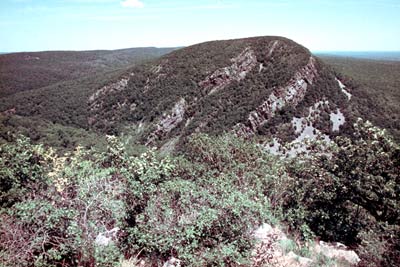
Mount Tammany 's south face, November 2008
|
|
| Highest point | |
| Elevation | Lua error in Module:Convert at line 1851: attempt to index local 'en_value' (a nil value). |
| Coordinates | Lua error in package.lua at line 80: module 'strict' not found. [1] |
| Geography | |

Mount Tammany
Location of Mount Tammany in New Jersey
|
|
| Location | Delaware Water Gap, Warren County, New Jersey, U.S. |
| Parent range | Kittatinny Mountains |
| Topo map | USGS Portland [1] |
| Climbing | |
| Easiest route | Mount Tammany Trail ascending the western slopes from the Dunnfield Creek trailhead (hike) |
Mount Tammany is the southernmost peak of the Kittatinny Mountains in Knowlton Township, Warren County, New Jersey, United States. It is 1,526 feet (465 m) tall, and forms the east side of the Delaware Water Gap. Across the Gap is Mount Minsi, on the Pennsylvania side of the river. The mountain is named after the Lenni Lenape chief Tamanend.[2] It lies along the Appalachian Trail in Worthington State Forest. The summit can be hiked by the Mount Tammany Trail ascending the western slopes. This trail head is accessible from Interstate 80.
References
External links
| Wikimedia Commons has media related to [[commons:Lua error in Module:WikidataIB at line 506: attempt to index field 'wikibase' (a nil value).|Lua error in Module:WikidataIB at line 506: attempt to index field 'wikibase' (a nil value).]]. |
<templatestyles src="Asbox/styles.css"></templatestyles>
|
This Warren County, New Jersey state location article is a stub. You can help Wikipedia by expanding it. |