File:PIA20014-Ceres-SurveyAtlas-AsariZadeni-June2015.jpg

Summary
PIA20014: Ceres Survey Atlas - June 2015
<a rel="nofollow" class="external free" href="http://photojournal.jpl.nasa.gov/catalog/PIA20014">http://photojournal.jpl.nasa.gov/catalog/PIA20014</a>
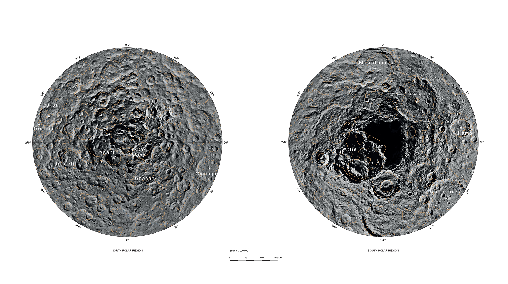
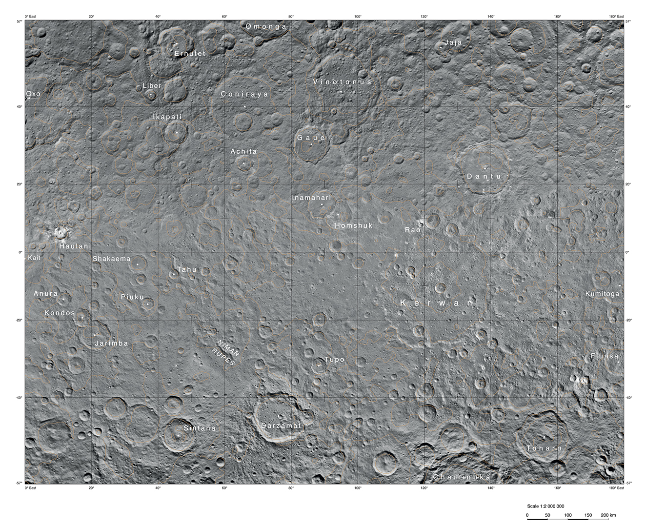
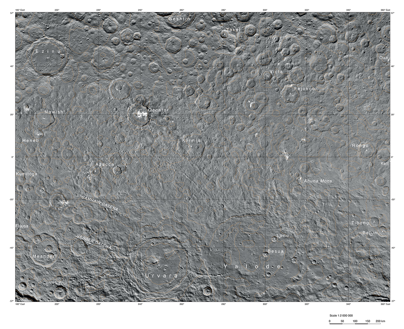
This atlas of Ceres was created using images taken by NASA's Dawn spacecraft in June 2015. Researchers used 12,000 points on Ceres to construct a terrain model, which served as the basis for these maps. Kait crater was chosen as the reference point for longitude 0.
The German Aerospace Center (DLR) constructed this atlas using data from Dawn's Survey orbit, when the spacecraft was at an altitude of about 2,700 miles (4,400 kilometers) above Ceres. The resolution is approximately 1,400 feet (410 meters) per pixel in the full-resolution PDF.
The Kerwan map section is centered on 0 degrees latitude, 90 east longitude. The Occator map section is centered on 0 degrees latitude, 270 east longitude. The Asari-Zadeni map section is centered above Ceres' north and south polar regions.
Asari-Zadeni - Map Section
<a rel="nofollow" class="external free" href="http://photojournal.jpl.nasa.gov/figures/PIA20014_fig1_Asari-Zadeni.jpg">http://photojournal.jpl.nasa.gov/figures/PIA20014_fig1_Asari-Zadeni.jpg</a>
<a rel="nofollow" class="external free" href="http://photojournal.jpl.nasa.gov/archive/PIA20014_fig1_Asari-Zadeni.pdf">http://photojournal.jpl.nasa.gov/archive/PIA20014_fig1_Asari-Zadeni.pdf</a>
Kerwan - Map Section
<a rel="nofollow" class="external free" href="http://photojournal.jpl.nasa.gov/figures/PIA20014_fig2_Kerwan.jpg">http://photojournal.jpl.nasa.gov/figures/PIA20014_fig2_Kerwan.jpg</a>
<a rel="nofollow" class="external free" href="http://photojournal.jpl.nasa.gov/archive/PIA20014_fig2_Kerwan.pdf">http://photojournal.jpl.nasa.gov/archive/PIA20014_fig2_Kerwan.pdf</a>
Occator - Map Section
<a rel="nofollow" class="external free" href="http://photojournal.jpl.nasa.gov/figures/PIA20014_fig3_Occator.jpg">http://photojournal.jpl.nasa.gov/figures/PIA20014_fig3_Occator.jpg</a>
<a rel="nofollow" class="external free" href="http://photojournal.jpl.nasa.gov/archive/PIA20014_fig3_Occator.pdf">http://photojournal.jpl.nasa.gov/archive/PIA20014_fig3_Occator.pdf</a>
Dawn's mission is managed by JPL for NASA's Science Mission Directorate in Washington. Dawn is a project of the directorate's Discovery Program, managed by NASA's Marshall Space Flight Center in Huntsville, Alabama. UCLA is responsible for overall Dawn mission science. Orbital ATK, Inc., in Dulles, Virginia, designed and built the spacecraft. The German Aerospace Center, the Max Planck Institute for Solar System Research, the Italian Space Agency and the Italian National Astrophysical Institute are international partners on the mission team. For a complete list of acknowledgments, see <a rel="nofollow" class="external free" href="http://dawn.jpl.nasa.gov/mission">http://dawn.jpl.nasa.gov/mission</a>.
For more information about the Dawn mission, visit <a rel="nofollow" class="external free" href="http://dawn.jpl.nasa.gov">http://dawn.jpl.nasa.gov</a>.
Licensing
Lua error in package.lua at line 80: module 'strict' not found.
File history
Click on a date/time to view the file as it appeared at that time.
| Date/Time | Thumbnail | Dimensions | User | Comment | |
|---|---|---|---|---|---|
| current | 13:19, 5 January 2017 | | 1,929 × 1,080 (1.14 MB) | 127.0.0.1 (talk) | PIA20014: Ceres Survey Atlas - June 2015 <p><a rel="nofollow" class="external free" href="http://photojournal.jpl.nasa.gov/catalog/PIA20014">http://photojournal.jpl.nasa.gov/catalog/PIA20014</a> </p> <p>This atlas of Ceres was created using images taken by NASA's Dawn spacecraft in June 2015. Researchers used 12,000 points on Ceres to construct a terrain model, which served as the basis for these maps. Kait crater was chosen as the reference point for longitude 0. </p> <p>The German Aerospace Center (DLR) constructed this atlas using data from Dawn's Survey orbit, when the spacecraft was at an altitude of about 2,700 miles (4,400 kilometers) above Ceres. The resolution is approximately 1,400 feet (410 meters) per pixel in the full-resolution PDF. </p> <p>The Kerwan map section is centered on 0 degrees latitude, 90 east longitude. The Occator map section is centered on 0 degrees latitude, 270 east longitude. The Asari-Zadeni map section is centered above Ceres' north and south polar regions. </p> <p><br> Asari-Zadeni - Map Section<br><a rel="nofollow" class="external free" href="http://photojournal.jpl.nasa.gov/figures/PIA20014_fig1_Asari-Zadeni.jpg">http://photojournal.jpl.nasa.gov/figures/PIA20014_fig1_Asari-Zadeni.jpg</a><br><a rel="nofollow" class="external free" href="http://photojournal.jpl.nasa.gov/archive/PIA20014_fig1_Asari-Zadeni.pdf">http://photojournal.jpl.nasa.gov/archive/PIA20014_fig1_Asari-Zadeni.pdf</a> </p> <p><br> Kerwan - Map Section<br><a rel="nofollow" class="external free" href="http://photojournal.jpl.nasa.gov/figures/PIA20014_fig2_Kerwan.jpg">http://photojournal.jpl.nasa.gov/figures/PIA20014_fig2_Kerwan.jpg</a><br><a rel="nofollow" class="external free" href="http://photojournal.jpl.nasa.gov/archive/PIA20014_fig2_Kerwan.pdf">http://photojournal.jpl.nasa.gov/archive/PIA20014_fig2_Kerwan.pdf</a> </p> <p><br> Occator - Map Section<br><a rel="nofollow" class="external free" href="http://photojournal.jpl.nasa.gov/figures/PIA20014_fig3_Occator.jpg">http://photojournal.jpl.nasa.gov/figures/PIA20014_fig3_Occator.jpg</a><br><a rel="nofollow" class="external free" href="http://photojournal.jpl.nasa.gov/archive/PIA20014_fig3_Occator.pdf">http://photojournal.jpl.nasa.gov/archive/PIA20014_fig3_Occator.pdf</a> </p> <p><br> Dawn's mission is managed by JPL for NASA's Science Mission Directorate in Washington. Dawn is a project of the directorate's Discovery Program, managed by NASA's Marshall Space Flight Center in Huntsville, Alabama. UCLA is responsible for overall Dawn mission science. Orbital ATK, Inc., in Dulles, Virginia, designed and built the spacecraft. The German Aerospace Center, the Max Planck Institute for Solar System Research, the Italian Space Agency and the Italian National Astrophysical Institute are international partners on the mission team. For a complete list of acknowledgments, see <a rel="nofollow" class="external free" href="http://dawn.jpl.nasa.gov/mission">http://dawn.jpl.nasa.gov/mission</a>. </p> For more information about the Dawn mission, visit <a rel="nofollow" class="external free" href="http://dawn.jpl.nasa.gov">http://dawn.jpl.nasa.gov</a>. |
| 13:19, 5 January 2017 |  | 1,929 × 1,080 (1.14 MB) | 127.0.0.1 (talk) | PIA20014: Ceres Survey Atlas - June 2015 <p><a rel="nofollow" class="external free" href="http://photojournal.jpl.nasa.gov/catalog/PIA20014">http://photojournal.jpl.nasa.gov/catalog/PIA20014</a> </p> <p>This atlas of Ceres was created using images taken by NASA's Dawn spacecraft in June 2015. Researchers used 12,000 points on Ceres to construct a terrain model, which served as the basis for these maps. Kait crater was chosen as the reference point for longitude 0. </p> <p>The German Aerospace Center (DLR) constructed this atlas using data from Dawn's Survey orbit, when the spacecraft was at an altitude of about 2,700 miles (4,400 kilometers) above Ceres. The resolution is approximately 1,400 feet (410 meters) per pixel in the full-resolution PDF. </p> <p>The Kerwan map section is centered on 0 degrees latitude, 90 east longitude. The Occator map section is centered on 0 degrees latitude, 270 east longitude. The Asari-Zadeni map section is centered above Ceres' north and south polar regions. </p> <p><br> Asari-Zadeni - Map Section<br><a rel="nofollow" class="external free" href="http://photojournal.jpl.nasa.gov/figures/PIA20014_fig1_Asari-Zadeni.jpg">http://photojournal.jpl.nasa.gov/figures/PIA20014_fig1_Asari-Zadeni.jpg</a><br><a rel="nofollow" class="external free" href="http://photojournal.jpl.nasa.gov/archive/PIA20014_fig1_Asari-Zadeni.pdf">http://photojournal.jpl.nasa.gov/archive/PIA20014_fig1_Asari-Zadeni.pdf</a> </p> <p><br> Kerwan - Map Section<br><a rel="nofollow" class="external free" href="http://photojournal.jpl.nasa.gov/figures/PIA20014_fig2_Kerwan.jpg">http://photojournal.jpl.nasa.gov/figures/PIA20014_fig2_Kerwan.jpg</a><br><a rel="nofollow" class="external free" href="http://photojournal.jpl.nasa.gov/archive/PIA20014_fig2_Kerwan.pdf">http://photojournal.jpl.nasa.gov/archive/PIA20014_fig2_Kerwan.pdf</a> </p> <p><br> Occator - Map Section<br><a rel="nofollow" class="external free" href="http://photojournal.jpl.nasa.gov/figures/PIA20014_fig3_Occator.jpg">http://photojournal.jpl.nasa.gov/figures/PIA20014_fig3_Occator.jpg</a><br><a rel="nofollow" class="external free" href="http://photojournal.jpl.nasa.gov/archive/PIA20014_fig3_Occator.pdf">http://photojournal.jpl.nasa.gov/archive/PIA20014_fig3_Occator.pdf</a> </p> <p><br> Dawn's mission is managed by JPL for NASA's Science Mission Directorate in Washington. Dawn is a project of the directorate's Discovery Program, managed by NASA's Marshall Space Flight Center in Huntsville, Alabama. UCLA is responsible for overall Dawn mission science. Orbital ATK, Inc., in Dulles, Virginia, designed and built the spacecraft. The German Aerospace Center, the Max Planck Institute for Solar System Research, the Italian Space Agency and the Italian National Astrophysical Institute are international partners on the mission team. For a complete list of acknowledgments, see <a rel="nofollow" class="external free" href="http://dawn.jpl.nasa.gov/mission">http://dawn.jpl.nasa.gov/mission</a>. </p> For more information about the Dawn mission, visit <a rel="nofollow" class="external free" href="http://dawn.jpl.nasa.gov">http://dawn.jpl.nasa.gov</a>. |
- You cannot overwrite this file.
File usage
The following 2 pages link to this file: