File:Pleistocene north ice map.jpg
From Infogalactic: the planetary knowledge core

No higher resolution available.
Pleistocene_north_ice_map.jpg (250 × 417 pixels, file size: 38 KB, MIME type: image/jpeg)
Summary
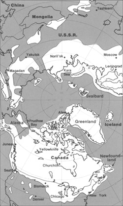
The maximum extent of glacial ice in the north polar area during Pleistocene time. Lua error in package.lua at line 80: module 'strict' not found. http://pubs.usgs.gov/gip/continents/map.jpg
Licensing
Lua error in package.lua at line 80: module 'strict' not found.
File history
Click on a date/time to view the file as it appeared at that time.
| Date/Time | Thumbnail | Dimensions | User | Comment | |
|---|---|---|---|---|---|
| current | 11:43, 5 January 2017 | | 250 × 417 (38 KB) | 127.0.0.1 (talk) | The maximum extent of glacial ice in the north polar area during Pleistocene time. {{PD-USGov-Interior-USGS}} http://pubs.usgs.gov/gip/continents/map.jpg |
- You cannot overwrite this file.
File usage
The following 3 pages link to this file: