Hooge in World War I

In World War I, the area around Hooge in one of the eastern-most sectors of the Ypres Salient was the site of intense and sustained fighting between German and Allied forces. The small village of Hooge is located on the Bellewaerde Ridge, about 4 kilometres east of Ypres in the Flemish province of West-Vlaanderen in Belgium.
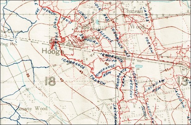
The sites of several significant military operations can be found within a 1 kilometre (0.62 mi) radius around Hooge, including those known in World War I as Château Wood, Sanctuary Wood, Railway Wood and Menin Road. There are four Commonwealth War Graves Commission (CWGC) war cemeteries in this area, as well as several museums and memorials. Hill 62 and Mount Sorrel are located further south, while the sites known to British and Commonwealth soldiers as Stirling Castle and Clapham Junction are further east.
Contents
Background
For much of the war, the region around Hooge belonged to one of the eastern-most sectors of the Ypres Salient, being almost constantly exposed to enemy attacks from three sides. From 1914 the front line of the salient ran through the Hooge area and there was almost constant fighting in the region over the next three years, during which the village of Hooge and the Château de Hooge, a local manor house which served as country house of the local landed gentry and residence of the lord of the manor, were totally destroyed.[1] Around Hooge, the opposing front lines were almost within whispering distance of each other. With its ruined village and a maze of battered and confusing trench lines, the area was regarded as a very hazardous and heavily contested area for the infantry, where snipers abounded and trench raids were frequent. Both sides saw Hooge as a particularly important area and a key target for heavy artillery bombardment.[2]
Battles
Autumn 1914
During the First Battle of Ypres (19 October – 22 November 1914), when the Allies captured the town of Ypres from the Germans, the Château de Hooge was used by the commanders of the 1st and 2nd Divisions for their joint divisional headquarters.[3] When the château was shelled by German forces on 31 October 1914, the commanders of both divisions (Major Generals S.H. Lomax and C.C. Monro) were injured, as were several members of their staffs, and some British soldiers were killed.[4] Lomax died of his wounds several months later. By the end of the battle in November 1914 the Germans had been driven back, but the front line of the Ypres Salient now ran around Hooge.[5]
1915–1917


During the Second Battle of Ypres (22 April – 25 May 1915), Hooge was the site of intense fighting as the British were forced to draw back from Zonnebeke, Veldhoek and the St Julien arc on 5–6 May 1915 to a carefully chosen and well-dug line of trenches closer to Ypres. This line was to define the Ypres Salient for over two years.[2] From 24–25 May 1915, the Battle of Bellewaarde was fought in the area until the German offensive could be brought to a halt on Tuesday 25 May 1915.[2] Between 24 May and 3 June 1915, German forces began to attack the Château de Hooge, and despite the firing of a large mine by the British on 19 July (see below), the Germans took control of Hooge and the surrounding area on 30 July.[6] This 30 July 1915 at Hooge also marked the first time when soldiers of the German Army used the flame thrower in a concerted action during battle. At 03.15 a.m. jets of flames from these new devices swept across the British trenches, which were occupied at that time by companies of the 8th Rifle Brigade.[1] In that area of the Western Front, the lines were just 4.5 metres (4.9 yd) apart. The casualties were caused mainly by soldiers being flushed into the open by the fire bursts and being shot by the enemy rather than from the fire bursts itself.[7] By July 1915 artillery had reduced the Château de Hooge to rubble and it was never rebuilt.[8]
The site of the château and the mine crater of 19 July 1915 were retaken by the British 6th Division on 9 August 1915,[4] reclaimed by the Germans on 16 June 1916 (for strategic developments in this area during June 1916, see Battle of Mont Sorrel) and retaken by the British on 31 July 1917 when the 8th Division managed to push past it by about a mile.[6] The British forces then held Hooge for nine months.
1918
The Germans retook Hooge in April 1918 as part of the Spring Offensive but were driven back from the area by the British on 28 September[4] as the offensive faltered.
Underground fighting
1915
From the spring of 1915, there was constant underground fighting in the Ypres Salient at Hooge, Hill 60, Railway Wood, Sanctuary Wood, St Eloi and The Bluff which required the deployment of new drafts of tunnellers for several months after the formation of the first eight tunnelling companies of the Royal Engineers.[9] As part of their efforts to gain control of the area, both sides exploded mines beneath the front line trenches at Hooge, the evidence of which are still visible today.[8] On 21 February 1915, the Germans exploded the first mine beneath the trenches at Hooge.[8]
As part of their continued operations against the Salient after the Second Battle of Ypres and the Battle of Bellewaarde, the German forces kept seeking to gain Hooge between 24 May and 3 June 1915.[6] In the grounds of the Château de Hooge was a German strongpoint which was proving particularly troublesome to the British forces defending the area. The redoubt had in fact been started by the British but had fallen into German hands.[5] Major S.H. Cowan, commanding officer of 175th Tunnelling Company, described the situation at Hooge in June 1915: "There is some urgent [mining] work to be done at once in a village [Hooge] on a main road east of Ypres. We hold one half and the job is to get the G[ermans] out of the other, failing that they may get us out and so obtain another hill top from which to overlook the land. It is a significant fact that all their recent attacks round Ypres have been directed on hill tops and have rested content on the same, without trying really hard to advance down the slopes towards us."[2]
In order to break the stalemate, Cowan's unit dug a tunnel about 66 yards (60 m) long[5] under the German position and placed a mine there. This occurred during a time of relative quiet on the British part of the Western Front, when few major assaults were made. Nonetheless, the average casualty rate for the British and Commonwealth forces was around 300 per day.[1] As Hooge was on the apex of the Ypres Salient, it was considered a most dangerous job and the British command initially relied on volunteers.[2] The officer in charge of tunneling and laying the mine was Lieutenant Geoffrey Cassels of 175th Tunnelling Company. He wrote: "[Hooge] was a small village in ruins on top of the ridge, Hooge meaning height, astride the Menin Road. On the north side of the road was a chateau with a separate annex standing in its own grounds by a large wood. Behind the chateau was Bellewarde Lake. In front of the chateau and east of the village proper were the racing stables (...). The stables were at the very apex of the salient. They were actually in our front line. The trenches were shallow and primitive, even the front line ones, and to reach the front lines some tunnels had been driven under the road and part of the ruins. No Man's Land between us and the Germans was littered with blackened corpses (...) and the stink was abominable. (...) Our objective was to sink a shaft, then tunnel under the chateau and annex and blow them up."[2] The work was completed in five and a half weeks. The first attempt at tunnelling for the mine, starting from within a stable, failed because the soil was too sandy. A second shaft was sunk from the ruins of a gardener's cottage nearby. The main tunnel was in the end 190 feet (58 m) long, with a branch off this after about 70 feet (21 m), this second tunnel running a further 100 feet (30 m) on. The intention was to blow two charges under the German concrete fortifications, although the smaller tunnel was found to be off course. The explosive—used for the first time by the British—was ammonal supported by gunpowder and guncotton, making the Hooge mine the largest mine of the war thus far built.[1] The main difficulties for the tunnellers were that the water table is very high, and that the clay expands as soon as it comes into contact with the air.[5]
At 7.00 p.m. on 19 July 1915 the mine was fired. The explosion created a hole some 6.6 yards (6 m) deep and almost 44 yards (40 m) wide.[5] The far side of the crater was then taken and secured by men from the 1st Battalion, Gordon Highlanders and 4th Battalion, Middlesex Regiment. Ten of the latter were killed by debris from the mine as they waited in advanced positions.[1] The Germans tried to recover their lost position but were driven back by the British infantry and a heavy artillery bombardment.[5] The mine fired by 175th Tunnelling Company at Hooge on 19 July 1915 was only the second British offensive underground attack in the Ypres Salient. On 17 April 1915, 173rd Tunnelling Company had blown five mines at Hill 60 using gunpowder and guncotton, but none of these mines were even half as powerful as the Hooge charge.[2] While the mine enabled the British infantry to take Hooge, the Germans soon took back all and more of the ground they had lost.[2] By 30 July the German units had managed to take control of the château and the surrounding area.[6]
When 177th Tunnelling Company arrived at Hooge in November 1915, underground warfare in the area was far from over.[2] One of the busiest areas for the miners on both sides was Railway Wood, an area at Hooge where the old Ypres-Roeselare railway crossed the Ypres-Menen road. Aerial photographs clearly show the proliferation of mine warfare in the Railway Wood sector during the unit's presence there, with craters lying almost exclusively in no man's land between the British and German trenches.[10] With both sides trying to undermine their enemy, much of the unit's activity at Railway Wood consisted of creating and maintaining a shallow fighting system with camouflets, a deeper defensive system as well as offensive galleries from an underground shaft.[11]
1916
On the morning of 28 April 1916, a German camouflet killed three men of 177th Tunnelling Company, including an officer (Lieutenant C.G. Boothby). The men were trapped underground and their bodies not recovered. After the war, they were commemorated nearby at the RE Grave, Railway Wood.
On 6 June 1916, the Germans detonated four mines beneath the British trenches at Hooge. After intense and sustained fighting, they also retook the crater created by the British mine on 19 July 1915 as well as the British front line.[8] The German surprise offensive also captured the neighbouring Observatory Ridge and Sanctuary Wood—the only high ground on British hands in the whole of the Ypres Salient. Canadian units later regained Observatory Ridge and Sanctuary Wood, but not Hooge.[2]
1917
While engaged at Hooge until August 1917, the 177th Tunnelling Company also built a forward accommodation scheme in the Cambridge Road sector along the rear edge of Railway Wood, halfway in between Wieltje and Hooge. The Cambridge Road dugout system was located within 100 metres (110 yd) of the front line. It was connected to the mining scheme beneath Railway Wood and eventually became one of the most complex underground shelter systems in the Ypres Salient. Its mined galleries were named after London streets for easy orientation.[12]
177th Tunnelling Company was involved in constructing new dugouts beneath the Menin Road in the centre of Hooge, located in between 175th TC's July 1915 mine crater and the stables of the destroyed Château de Hooge.[13] Parts of these dugouts now lie beneath the Hooge Crater CWGC Cemetery opposite the "Hooge Crater Museum". Further projects of the 177th Tunnelling Company in the area were the Birr Cross Roads dugout and dressing station beneath the Menin Road further west of Hooge,[14] and the Canal Dugouts along the Ieperlee.[15] Fighting in the Hooge sector continued until 1918, with the craters (strategically important in relatively flat countryside) frequently changing sides.[6]
Commemoration
Hooge and Bellewaerde
Among those killed in the fighting in Hooge was Gerard Anderson, the British hurdler who participated in the 1912 Stockholm Olympics and died in November 1914.[16][17]
Although the crater created in Hooge by the British mine on 19 July 1915 was filled in after the war as untenable and the repository of hundreds of bodies, several other large mine craters that were created over the course of the fighting[18] can still be seen. The most visible evidence remaining today is a large pond near the hotel and restaurant at the Bellewaerde theme park. The site is the result of work overseen by Baron de Wynck, who landscaped three mine craters (blown by German units in June 1916 as part of their offensive against Canadian troops) into the existing pond near the hotel (image). Further craters can be found in and around Hooge, Bellewaerde Ridge and Railway Wood.
The "Hooge Crater Museum", founded in 1994, is located opposite Hooge Crater CWGC.[19] To the west of Hooge is the "Menin Road Museum".
- Hooge Crater Cemetery: Hooge became the location for a war cemetery in October 1917.[19] Among the soldiers buried here is Patrick Bugden VC (1897–1917), killed during the Battle of Polygon Wood.
- Memorial to the King's Royal Rifle Corps, Hooge
- Birr Cross Roads Cemetery is located along the Menin Road, just west of Hooge. There are now 833 Commonwealth soldiers buried or commemorated here, of which 334 are unidentified.[20]
- Memorial to Princess Patricia's Canadian Light Infantry, Westhoek
Railway Wood
- Liverpool Scottish Memorial, Railway Wood
- RE Grave, Railway Wood: A short distance north-west of Hooge. The memorial marks the spot where twelve soldiers (eight Royal Engineers of the 177th Tunnelling Company and four attached infantrymen) were killed between November 1915 and August 1917 while tunnelling under the hill near Hooge during the defence of Ypres; their bodies were not recovered.[21][22] One of the twelve men commemorated here is Second Lieutenant Charles Geoffrey Boothby (1894–1916), whose wartime letters to his girlfriend were published in 2005.[23]
Sanctuary Wood
An extensive woodland, known locally as 'Drieblotenbos Hoge Netelaar', but called 'Sanctuary Wood' by British soldiers who took refuge here in November 1914.
- Sanctuary Wood Cemetery
- Sanctuary Wood Museum Hill 62
- Memorial to Lieutenant Keith Rae
- Canadian Hill 62 (Sanctuary Wood) Memorial, located beside Sanctuary Wood on the top of Mount Sorrel, which lies next to Hill 62. All of these are locations the Canadians held or recaptured from the Germans during the offensive operations in early June 1916.
Notes
- ↑ 1.0 1.1 1.2 1.3 1.4 Hooge on ww1battlefields.co.uk, accessed 25 April 2015
- ↑ 2.0 2.1 2.2 2.3 2.4 2.5 2.6 2.7 2.8 2.9 Peter Barton/Peter Doyle/Johan Vandewalle, Beneath Flanders Fields - The Tunnellers' War 1914–1918, Staplehurst (Spellmount) (978-1862272378) pp. 148–154.
- ↑ Duffy, Michael firstworldwar.com 25 August 2002, accessed 16 February 2007
- ↑ 4.0 4.1 4.2 Commonwealth War Graves Commission, undated, accessed 16 February 2007
- ↑ 5.0 5.1 5.2 5.3 5.4 5.5 http://www.webmatters.net/belgium/ww1_hooge.htm access date 24 April 2015
- ↑ 6.0 6.1 6.2 6.3 6.4 Battlefields 14-18, undated, accessed 16 February 2007
- ↑ First World War, Willmott, H.P., Dorling Kindersley, 2003, Page 106
- ↑ 8.0 8.1 8.2 8.3 With the British Army in Flanders: Hooge Crater, access date 26 April 2015.
- ↑ Peter Barton/Peter Doyle/Johan Vandewalle, Beneath Flanders Fields - The Tunnellers' War 1914–1918, Staplehurst (Spellmount) (978-1862272378) p. 165.
- ↑ Peter Barton/Peter Doyle/Johan Vandewalle, Beneath Flanders Fields - The Tunnellers' War 1914–1918, Staplehurst (Spellmount) (978-1862272378) p. 123.
- ↑ Peter Barton/Peter Doyle/Johan Vandewalle, Beneath Flanders Fields - The Tunnellers' War 1914–1918, Staplehurst (Spellmount) (978-1862272378) p. 119.
- ↑ Peter Barton/Peter Doyle/Johan Vandewalle, Beneath Flanders Fields - The Tunnellers' War 1914–1918, Staplehurst (Spellmount) (978-1862272378) pp. 216–218.
- ↑ Peter Barton/Peter Doyle/Johan Vandewalle, Beneath Flanders Fields - The Tunnellers' War 1914–1918, Staplehurst (Spellmount) (978-1862272378) p. 150 (see the trench map there).
- ↑ Peter Barton/Peter Doyle/Johan Vandewalle, Beneath Flanders Fields - The Tunnellers' War 1914–1918, Staplehurst (Spellmount) (978-1862272378) p. 262.
- ↑ Peter Barton/Peter Doyle/Johan Vandewalle, Beneath Flanders Fields - The Tunnellers' War 1914–1918, Staplehurst (Spellmount) (978-1862272378) p. 228.
- ↑ ANDERSON, GERARD RUPERT LAURIE. Commonwealth War Graves Commission.
- ↑ ENGLAND LOSING ATHLETES; Many Prominent in Sporting Circles Die on Battle Fields. New York Times. Dec 1, 1914
- ↑ WWI Battlefields, undated, accessed 16 February 2007
- ↑ 19.0 19.1 firstworldwar.com Hooge Museum
- ↑ CWGC Cemetery Details: Birr Cross Roads Cemetery
- ↑ www.wo1.be accessed 19 June 2006
- ↑ wo1.be, accessed 19 June 2006
- ↑ Arthur Stockwin (ed.), Thirty-odd Feet Below Belgium: An Affair of Letters in the Great War 1915–1916, Parapress (2005), ISBN 978-1-89859-480-2 (online)
External links
- With the British Army in Flanders: Hooge Crater (with image gallery)
- This day in history: Battle of Hooge
- Battle map of Hooge with locations of trenches
- Battle map of Hooge with mine craters indicated
Lua error in package.lua at line 80: module 'strict' not found.