File:SE2015Mar20T.png
From Infogalactic: the planetary knowledge core

Size of this preview: 599 × 600 pixels. Other resolutions: 240 × 240 pixels | 728 × 729 pixels.
Original file (728 × 729 pixels, file size: 27 KB, MIME type: image/png)
Summary
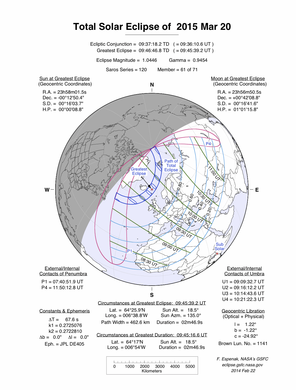
<a href="https://en.wikipedia.org/wiki/Solar_eclipse" class="extiw" title="en:Solar eclipse">Solar eclipse</a> A map of path on earth: Totality exists within the dark blue areas, partiality at the light blue areas. The eclipse occurs at sunrise or sunset in the pink areas. Light blue lines represent a constant fixed fraction of coverage. Green lines show lines of time for greatest coverage. For more information see <a rel="nofollow" class="external autonumber" href="http://eclipse.gsfc.nasa.gov/SEplot/SEplot2001/SE2015Mar20T.GIF">[1]</a>
Licensing
Lua error in package.lua at line 80: module 'strict' not found.
File history
Click on a date/time to view the file as it appeared at that time.
| Date/Time | Thumbnail | Dimensions | User | Comment | |
|---|---|---|---|---|---|
| current | 07:04, 12 January 2017 | | 728 × 729 (27 KB) | 127.0.0.1 (talk) | <a href="https://en.wikipedia.org/wiki/Solar_eclipse" class="extiw" title="en:Solar eclipse">Solar eclipse</a> A map of path on earth: Totality exists within the dark blue areas, partiality at the light blue areas. The eclipse occurs at sunrise or sunset in the pink areas. Light blue lines represent a constant fixed fraction of coverage. Green lines show lines of time for greatest coverage. For more information see <a rel="nofollow" class="external autonumber" href="http://eclipse.gsfc.nasa.gov/SEplot/SEplot2001/SE2015Mar20T.GIF">[1]</a> |
- You cannot overwrite this file.
File usage
The following 39 pages link to this file:
- Solar eclipse of April 11, 2051
- Solar eclipse of April 21, 2069
- Solar eclipse of August 11, 2018
- Solar eclipse of August 12, 2026
- Solar eclipse of August 12, 2045
- Solar eclipse of August 12, 2064
- Solar eclipse of August 13, 2083
- Solar eclipse of August 21, 2017
- Solar eclipse of February 15, 1961
- Solar eclipse of February 15, 2018
- Solar eclipse of February 26, 1979
- Solar eclipse of February 26, 2017
- Solar eclipse of February 4, 1943
- Solar eclipse of January 1, 1889
- Solar eclipse of January 14, 1907
- Solar eclipse of January 24, 1925
- Solar eclipse of January 5, 2038
- Solar eclipse of January 5, 2057
- Solar eclipse of January 6, 2019
- Solar eclipse of January 6, 2076
- Solar eclipse of June 1, 2011
- Solar eclipse of June 1, 2030
- Solar eclipse of June 1, 2087
- Solar eclipse of March 19, 2072
- Solar eclipse of March 20, 2034
- Solar eclipse of March 20, 2053
- Solar eclipse of March 30, 2033
- Solar eclipse of March 9, 1997
- Solar eclipse of May 2, 2087
- Solar eclipse of May 31, 2049
- Solar eclipse of May 31, 2068
- Solar eclipse of October 24, 2060
- Solar eclipse of October 24, 2079
- Solar eclipse of October 25, 2022
- Solar eclipse of September 1, 2016
- Solar eclipse of September 13, 2015
- Template:Solar Metonic series 2011 June 1
- Template:Solar Saros series 120
- Template:Solar eclipse set 2015-2018